Lodging nearby Apartmani Elio
Croatia
Lodging nearby Apartmani Elio
Apartmani Elio
38, Kastavska ulica, 52100, Pula, Općina Pula, HR Croacia
contacts phone
:
+385
Latitude:
44.8832187
, Longitude:
13.8599074
larger map & directions
read more
nearest Lodging
44 m
Holiday Home Ermanna
Vitasovi?eva 11, Pula
Lodging
read more
85 m
Relax Apartment Ive
Vitasovićeva ulica 30, Pula
Lodging
read more
150 m
Apartment Benciceva 01
Pula
Lodging
read more
171 m
Ferienwohnung Debora
66 Benčićeva ulica Eingang 66E, Pula
Lodging
read more
187 m
Hedona Apartments
Benčićeva ulica 64, Pula
Lodging
read more
199 m
Studio Apartment Raspar
Braće Levak 12, Pula
Lodging
read more
229 m
Pula Comfort Apartments
Ulica Braća Levaka 8, Pula
Lodging
read more
234 m
Apartment Ivan
Vitasovićeva 1 A, Pula
Lodging
read more
269 m
Apartment Bonaca
Kastavska ulica 10, Pula
Lodging
read more
630 m
Cool Book Hostel
Valica ulica, Pula
Lodging
read more
1.017 km
Apartment Casa Verde
Vernalska 29, Pula
Lodging
read more
1.037 km
Apartment Grbac
Vernalska 3, Pula
Lodging
read more
1.548 km
Apartment Dreamy Garden
Vernalska 22, Pula
Lodging
read more
1.668 km
Apartment Dada
Epulonova ulica 1.kat broj zgrade 29, Pula
Lodging
read more
1.679 km
Apartments Luana
Zadarska 8, Pula
Lodging
read more
1.708 km
Pula Urban Delight
Istarska 2, Pula
Lodging
read more
1.744 km
Hotel Omir
Dobricheva ulica 6, Pula
Lodging
read more
1.785 km
Amu Apartment
Giardini 11, Pula
Lodging
read more
1.928 km
Apartment Isabella 640
44 Borik, Pula
Lodging
read more
1.939 km
Apartment Borik
Borik 48, Pula
Lodging
read more
1.948 km
Apartman Lena
Flanatička 10 3a, 1.kat, Pula
Lodging
read more
1.981 km
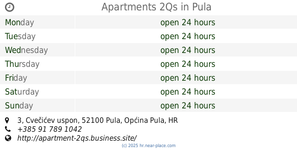
Apartments 2Qs
Cvečićev uspon 3, Pula
Lodging
read more
1.999 km
Apartments Universe
VALTURA 121, Pula
Lodging
read more
2.034 km
Apartment Sandra
Francesco Sponza 59 Francesco Sponza 59, Pula
Lodging
read more
2.06 km
Apartament Jovic
Paduljski put 70, Pula
Lodging
read more
📑
all categories
Accounting
Administrative area level 1
Administrative area level 2
Airport
Amusement park
Aquarium
Art gallery
Atm
Bakery
Bank
Bar
Beauty salon
Bicycle store
Book store
Bowling alley
Bus station
Cafe
Campground
Car dealer
Car rental
Car repair
Car wash
Casino
Cemetery
Church
City hall
Clothing store
Convenience store
Courthouse
Dentist
Department store
Doctor
Electrician
Electronics store
Embassy
Finance
Fire station
Florist
Food
Funeral home
Furniture store
Gas station
General contractor
Grocery or supermarket
Gym
Hair care
Hardware store
Health
Home goods store
Hospital
Insurance agency
Jewelry store
Laundry
Lawyer
Library
Light rail station
Liquor store
Local government office
Locality
Locksmith
Lodging
Meal delivery
Meal takeaway
Mosque
Movie rental
Movie theater
Moving company
Museum
Natural feature
Neighborhood
Night club
Painter
Park
Parking
Pet store
Pharmacy
Physiotherapist
Place of worship
Plumber
Point of interest
Police
Post office
Premise
Real estate agency
Restaurant
Roofing contractor
Route
Rv park, camping
School
Shoe store
Shopping mall
Spa
Stadium
Storage
Store
Supermarket
Synagogue
Taxi stand
Train station
Transit station
Travel agency
University
Veterinary care
Zoo
administrative area level 3
sublocality level 1
↑